Maps with decimal distances
key notes :
| Maps and Distances |
- A map is a drawing that shows places and their positions.
- On a map, distances are shown using a scale (e.g., 1 cm on map = 2 km in real life).
| Decimal Distances |
- Distances in real life are not always whole numbers.
- We often use decimals to show smaller parts of a unit (like 2.5 km, 3.75 km, 12.4 km).
| Using Scale with Decimals |
Multiply the map measurement (in cm) by the scale to find the actual distance.
- Example: If scale = 1 cm = 1.5 km, and map distance = 4.2 cm →
- Actual distance = 4.2 × 1.5 = 6.3 km.
| Adding and Subtracting Decimal Distances |
When finding total distance (like two routes), add decimals.
- Example: 2.4 km + 3.65 km = 6.05 km.
| Comparing Decimal Distances |
Use place value to compare.
- Example: 7.25 km > 7.05 km because 25 hundredths > 5 hundredths.
| Word Problems with Decimal Distances |
Real-life problems often involve decimals in travel distances.
- Example: A person walks 3.5 km to school and 2.75 km to the market. Total distance walked = 3.5 + 2.75 = 6.25 km.
| 📏 Examples |
- On a map, the distance between Town A and Town B is 6.4 cm.
Scale: 1 cm = 2.5 km.
→ Actual distance = 6.4 × 2.5 = 16 km. - A road is 5.75 km long, and another road is 3.2 km long.
Total = 5.75 + 3.2 = 8.95 km. - A student cycles 4.8 km, then walks 2.65 km.
Total distance = 4.8 + 2.65 = 7.45 km.
| 📝 Practice Questions |
- A map shows 7.2 cm between two villages. Scale = 1 cm = 1.8 km. What is the real distance?
- A bus travels 12.5 km in the morning and 8.75 km in the evening. What is the total distance?
- Which is farther: 9.05 km or 9.5 km?
- The real distance is 24.6 km. On a map, the scale is 1 cm = 3 km. What is the map distance?
- A person runs 2.45 km, then walks 1.85 km. What is the total distance?
Learn with an example
▶️ Using the paths shown, the distance from Belmont to Allenville is 6.5 kilometers.
How far is it from Booneville to Allenville?
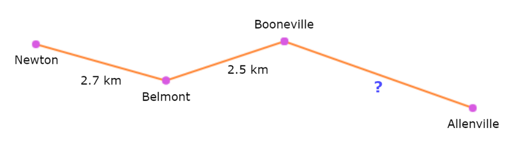
To find the total distance, add up the paths:
| Belmont to Booneville | 2.5 km |
| Booneville to Allenville | ? |
You already know the total distance is 6.5 kilometers, so solve for the missing
distance:
2.5 + ? = 6.5
? = 6.5 − 2.5
? = 4
So, the distance from Booneville to Allenville is 4 kilometers.
▶️ Using the paths shown, the distance from Hillsboro to Georgetown is 4.3 kilometers.
How far is it from Hillsboro to Milford?
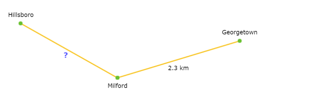
To find the total distance, add up the paths:
| Hillsboro to Milford | ? | |
| Milford to Georgetown | 2.3 km |
You already know the total distance is 4.3 kilometers, so solve for the missing
distance:
? + 2.3 = 4.3
? = 4.3 − 2.3
? = 2
So, the distance from Hillsboro to Milford is 2 kilometers.
🔥Using the paths shown, how far is it from Oxford to Dayton?
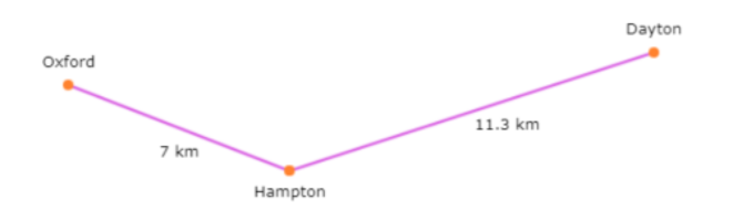
______ km
To find the total distance, add up the paths:
Oxford to Hampton 7 km
Hampton to Dayton 11.3 km
7 + 11.3 = 18.3
So, the total distance from Oxford to Dayton is 18.3 kilometres.
Let’s practice!